


From Düsseldorf , Germany to the of the Middle East, Abdul Khaleq Al-Qasaily is redefining how we see — and manage — our world from above. As Founder & CEO of SpaceGeoAI, he blends the power of Earth Observation satellites with cutting-edge AI to deliver real-time insights for infrastructure, environment, and urban growth. With over two decades of geospatial expertise across Europe, MENA, and Africa, Abdul Khaleq is on a mission to turn space data into on-the-ground impact, aligning technology with national visions like Saudi Arabia’s Vision 2030 and Oman’s Vision 2040.
What motivated the founding of SpaceGeoAI, and what specific problems are you aiming to solve within the geospatial AI space?

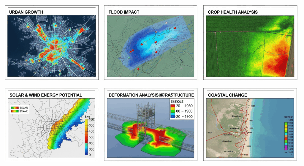
SpaceGeoAI was founded to make advanced Earth Observation and GeoAI effortless to integrate and be actionable at scale. Many organizations have access to EO data but lack the tooling to turn it into operational intelligence. Our solutions—spanning Infrastructure Intelligence, Environmental & Climate Intelligence, Urban & Land Analytics, Agriculture & Water Intelligence, Coastal & Marine Monitoring, and Disaster Risk & Resilience—bridge this gap by delivering ready-to-use analytics, clear dashboards, and APIs that support faster, smarter, and more sustainable decisions.
How do you envision SpaceGeoAI’s role evolving in the Earth observation and GeoAI ecosystem over the next 3–5 years?
We aim to be a trusted partner for AI-powered monitoring across Europe, MENA, and Africa. Our roadmap focuses on deeper automation, near real-time EO ingestion, and predictive models for early warnings across our solution areas: infrastructure condition and deformation, environmental risk, urban growth, water and agriculture efficiency, coastal change, and disaster impact. The goal is to operationalize climate resilience and asset intelligence for public and private stakeholders.
What are your core technological capabilities—do you develop proprietary AI models for geospatial analysis, or do you integrate third-party tools?
We use a hybrid approach. We build proprietary models tailored to our solution stack—e.g., multi-temporal change detection, InSAR-based deformation analytics, land-use/land-cover mapping, anomaly detection for assets, flood and wildfire mapping—while integrating best-in-class cloud and geospatial platforms for scalability and interoperability. This ensures clients get innovation without compromising reliability or integration with existing workflows.
What types of satellite data (e.g., optical, SAR, thermal) do you work with most frequently, and how do you ensure data quality and reliability?
We tailor our data stack to each solution area, fusing multi-sensor satellite data with aerial, in-situ, and mobility feeds:
- Earth Observation & Monitoring (Environmental Monitoring & Assessment, Natural Resource Management, Agriculture & Precision Farming, Disaster Management & Emergency Response, Urban Expansion & Infrastructure Planning):
- Optical/multispectral (e.g., Sentinel-2, high-res commercial) for land cover, vegetation, water quality proxies, and urban change.
- SAR (e.g., Sentinel-1) for all-weather flood mapping, soil moisture proxies, deformation/change, and damage assessment.
- Thermal/mid-IR for crop water stress, urban heat islands, and fire detection; nighttime lights for human activity proxies.
- Elevation/terrain (DEM) and ancillary GIS layers for hydrology, slope/aspect, and exposure modeling.
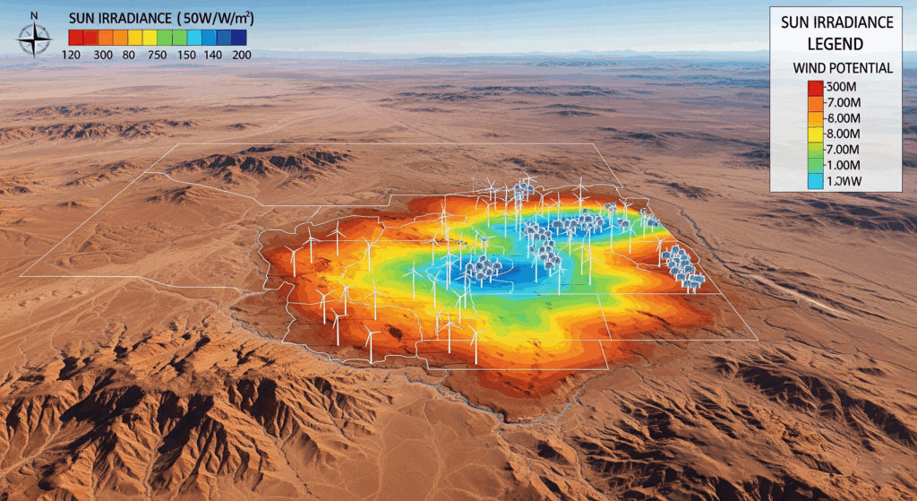
- Renewable Energy:
- Solar irradiance and cloud climatology derived from multispectral time series; thermal for surface temperature context.
- SAR and reanalysis for wind resource mapping; DEM for terrain shading and wake effects.
- Land-use, protected areas, and grid proximity layers for constraints-aware siting and EIA support.
- Urban & Infrastructure Development:
- High-resolution optical for asset condition and ROW monitoring; SAR/InSAR for structural stability and ground deformation.
- DEM/LiDAR (where available) for cut-and-fill, drainage, and engineering feasibility.
- Climate & Sustainability:
- Long-term EO time series (optical/SAR/thermal) and hazard layers for risk assessment, trend analysis, and adaptation planning.
- Smart Cities, Supply Chain & Logistics, Mobility & Transportation, Sports Events & Crowd Management:
- EO provides environmental, land-use, and infrastructure context; we complement it with GPS probe data, mobile-derived mobility insights, AIS/ADS-B, traffic sensors, and camera/computer vision feeds for real-time operations.
Quality and reliability are enforced through:
- Sensor-specific preprocessing: atmospheric correction, cloud/shadow masking, BRDF normalization, sub-pixel co-registration; SAR radiometric calibration, speckle filtering, and terrain correction; InSAR coherence screening.
- Multi-temporal compositing, cross-sensor harmonization, and outlier filtering; uncertainty quantification per product.
- Multi-source validation against ground truth, IoT, and independent datasets; human-in-the-loop QA for sensitive outputs.
- Robust MLOps: dataset and model versioning, drift monitoring, automated QC checks, and SLA-backed, cloud-native pipelines with redundancy across constellations.
Can you share specific use cases where your platform or technology has delivered measurable value?
Our use cases map directly to our solution portfolio:
- Earth Observation & Monitoring:
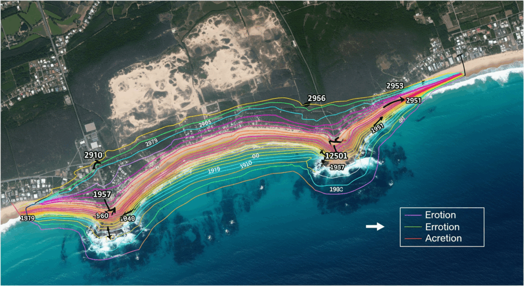
- Environmental Monitoring & Assessment: Continuous wetland, forest, and water-body health tracking to support ESG reporting and regulatory compliance.
- Natural Resource Management: Detection of illegal encroachment and optimized allocation of water and land resources for sustainable utilization.
- Agriculture & Precision Farming: Crop vigor and irrigation recommendations that cut scouting time and water use while protecting yields.
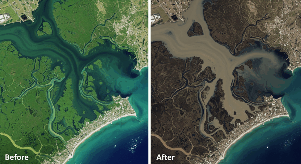
- Disaster Management & Emergency Response: Near real-time flood/wildfire extent and impact maps that accelerate response and focus relief.
- Urban Expansion & Infrastructure Planning: Automated urban sprawl and land-use change intelligence that streamlines zoning and permitting.
- Renewable Energy:
- Precise site selection for solar and wind using irradiance/wind climatology, terrain, grid proximity, and exclusion zones—shortening feasibility cycles.
- Resource assessments and short-term forecasting that improve energy yield planning and O&M scheduling.
- Environmental impact screening that reduces permitting risk and supports low-ecological-footprint design.
- Urban & Infrastructure Development:
- Advanced site suitability for new corridors and facilities incorporating hazards, access, and environmental constraints.
- Infrastructure monitoring & asset management (InSAR + optical) to prioritize maintenance and reduce unplanned outages.
- Risk assessment & mitigation with flood, landslide, and heat exposure analytics embedded into design decisions.
- Climate & Sustainability:
- Climate modeling and EO-driven trend analysis to map risk hotspots and guide adaptation strategies.
- Environmental risk assessments for nature-based solutions siting and resilient land-use planning.
- Disaster monitoring & response pipelines integrated with operations centers.
- Smart Cities:
- Urban planning optimization leveraging land-use, mobility, and heat-island layers to balance growth and livability.
- Traffic and infrastructure analytics that identify bottlenecks and inform targeted upgrades.
- Resource efficiency dashboards for water, waste, and energy operations.
- Supply Chain & Logistics:
- Route optimization that fuses weather hazards, congestion, and EO-derived disruptions to improve ETA accuracy and reduce costs.
- Inventory and resource planning using geospatial demand signals and risk forecasts.
- Mobility & Transportation:
- Congestion analytics and signal timing insights that improve travel-time reliability and safety.
- Public transport optimization via OD patterns and accessibility mapping to increase coverage and ridership.
- GeoAnalytics & Business Intelligence:
- Market and customer insights from footfall, demographics, and geospatial context to optimize network expansion.
- Predictive geo-analytics for site selection, risk scoring, and demand forecasting.
- Sports Events & Crowd Management:
- Real-time crowd density and flow monitoring from camera/computer vision and sensors to enhance safety.
- Predictive bottleneck detection and incident alerts that improve evacuation readiness and fan experience.
Across these deployments, clients typically see faster time-to-insight, reduced operational risk and costs, improved compliance, and better resource utilization—turning complex geospatial data into clear, decision-ready intelligence.
Which industries or sectors are your primary targets, and are your current engagements more with government, enterprise, or research clients?
We target sectors that map directly to our solution areas:
- Public sector and regulators: environment ministries, water authorities, disaster management agencies, urban planning and transport directorates.
- Critical infrastructure and utilities: road/rail operators, ports/airports, oil and gas pipelines, power and water utilities.
- Renewable energy: developers, IPPs, EPCs, and grid operators for solar and wind siting, resource assessment, and EIA support.
- Urban and smart city programs: municipalities and city operations for planning, mobility, and resource efficiency.
- Agriculture and natural resources: agri-cooperatives, agritech platforms, and resource managers.
- Supply chain, logistics, and mobility: 3PLs, last-mile operators, and transit agencies.
- Private enterprises using GeoAnalytics & Business Intelligence: retail, telco, and financial services.
- Event venues and organizers: stadiums and public safety teams for Sports Events & Crowd Management.
Our current mix is balanced, with a strong base in government and public-sector engagements, growing enterprise programs in energy, infrastructure, and logistics, and selective research collaborations with universities and system integrators to localize models and accelerate deployment.
Are you currently focusing on the European market, or are you expanding into high-growth regions such as MENA, Africa, or Southeast Asia?
Europe remains a core market. In parallel, we are scaling across MENA and Africa where our solutions have immediate fit:
- MENA: Smart cities, renewable energy acceleration, infrastructure monitoring, mobility analytics, environmental and coastal resilience.
- Africa: Agriculture and water efficiency, disaster monitoring and response, infrastructure corridors, urban expansion and land management. We are also engaging prospective partners in Southeast Asia for coastal risk, logistics, and urban growth use cases, with a focus on pilots that leverage our Earth Observation & Monitoring, Urban & Infrastructure Development, and Supply Chain & Logistics solutions.
What is your strategic interest in the Middle East, and how do you see your solutions contributing to regional initiatives?
The Middle East’s investment in giga-projects, renewable energy, water security, and smart mobility aligns directly with our solution stack:
- Renewable Energy: GeoAI-driven site selection, resource assessments, and environmental impact screening shorten development cycles and de-risk permitting.
- Urban & Infrastructure Development: Suitability analysis, infrastructure monitoring, and risk mitigation support resilient, climate-aware growth.
- Climate & Sustainability: Hazard mapping, environmental risk assessment, and adaptation planning help authorities meet national climate targets.
- Smart Cities and Mobility & Transportation: Traffic analytics, public transport optimization, and resource efficiency improve urban livability.
- Earth Observation & Monitoring: Environmental monitoring, disaster readiness (floods, wildfires, sandstorms), and urban expansion tracking inform policy and operations.
- Sports Events & Crowd Management: Real-time crowd analytics and incident detection enhance safety at major events. These capabilities support national visions such as Saudi Vision 2030 and Oman Vision 2040 by improving safety, accelerating infrastructure delivery, and enabling sustainable development.
You participated in the SpaceUp Competition organized by the Saudi Space Agency and CST—can you share more details?
We were proud to participate in the SpaceUp Competition organized by the Saudi Space Agency and the Communications, Space & Technology Commission (CST). We demonstrated how our Earth Observation & Monitoring, Urban & Infrastructure Development, Renewable Energy, and Disaster Management solutions can deliver operational value—such as rapid flood mapping, infrastructure deformation insights, and renewables siting. The program helped us engage with regional stakeholders, validate local use cases, and explore partnerships for pilots and scale-up in the MENA market.
What are your short-term priorities, and how can potential partners or clients support your growth?
Near-term priorities:
- Scale deployments across MENA and Africa in infrastructure monitoring, renewable energy siting, environmental risk, disaster response, and smart mobility.
- Localize our models with regional data, enhance real-time ingestion and forecasting, and productize solution modules with clear SLAs and APIs.
- Expand partnerships with ministries, municipalities, utilities, energy developers, logistics operators, venue managers, and system integrators.
How partners can help:
- Collaborate on procurement, integrations, and co-selling to accelerate adoption and impact
- Co-develop pilots and production rollouts in our core solution areas.
- Provide data partnerships (EO, mobility, IoT) to strengthen model accuracy and coverage.
You can request more info via abq.ceo@spacegeoai.com