


To the human eye, the Earth from space is a beautiful blueprint of swirling blue oceans, white clouds, and green landscapes. However, our eyes only capture a tiny fraction of the electromagnetic spectrum. Traditional optical satellite imagery replicates this human perspective, but it remains limited by atmospheric haze, thick smoke, and the inability to differentiate materials that look identical in visible light.
Enter Short-Wave Infrared (SWIR) technology. Operating in the wavelength band between roughly 1.0mu and 3.0mu, SWIR bridges the gap between visible light and thermal infrared. Unlike thermal imaging, which measures heat emitted by an object, SWIR consists of reflected light, behaving much like visible light but interacting with matter in profoundly unique ways. Today, spaceborne SWIR sensors are revolutionizing everything from disaster response to defense intelligence and mineral exploration.
Why SWIR is a Game-Changer
SWIR radiation interacts with the molecular composition of objects rather than just their surface color. This unlocks several distinct capabilities for Earth observation:
- Smoke and Haze Penetration: SWIR wavelengths are significantly longer than visible light waves. This allows them to bypass small particulate matter, like smoke, dust, and coastal haze, via Mie scattering physics, offering a crystal-clear view of the ground when optical sensors see only gray walls.
- Moisture Sensitivity: Water strongly absorbs SWIR light. Therefore, the presence of moisture completely alters how a material reflects SWIR wavelengths, making it an exceptional tool for tracking drought, crop health, and flooding.
- Material and Mineral Discrimination: Many natural and artificial materials exhibit unique chemical absorption features within the SWIR spectrum, allowing orbital sensors to distinguish between camouflage and vegetation, or identify specific geological compositions without requiring fieldwork.
Leading Examples of SWIR-Equipped Satellites
Several prominent Earth observation programs rely on SWIR sensors to deliver critical planetary insights.
1. Maxar’s WorldView-3
Launched in 2014, WorldView-3 remains a commercial gold standard for high-resolution Earth imaging. In addition to standard high-resolution panchromatic and multispectral bands, it carries 8 specialized SWIR bands. According to technical documentation on ESA Earth Online’s WorldView Overview, it can achieve a spatial resolution of up to 3.7 meters in the SWIR spectrum, allowing users to identify specific materials, minerals, and artificial structures from hundreds of kilometers away.
2. USGS/NASA Landsat 8 and Landsat 9
The venerable Landsat program has long championed infrared imaging. Both Landsat 8 and Landsat 9 carry the Operational Land Imager (OLI), which includes two dedicated SWIR bands (SWIR 1 at $1.57–1.65\,\mu\text{m}$ and SWIR 2 at $2.11–2.29\,\mu\text{m}$). As detailed by the USGS Landsat 9 Mission Page and NASA Science, its carefully calibrated 30-meter resolution serves as the scientific “gold standard” for open-access environmental and land resource tracking.
3. ESA’s Sentinel-2 Constellation
The European Space Agency’s Sentinel-2 mission consists of twin satellites (Sentinel-2A and 2B) providing high-revisit multi-spectral data. According to the Copernicus Data Space Ecosystem, Sentinel-2 utilizes SWIR bands (Bands 11 and 12) at a 20-meter resolution, proving instrumental in tracking global vegetation changes, agricultural health, and emergency disaster management free of charge.
4. LatConnect 60’s SWIRSAT Constellation
An exciting development in commercial Earth observation is the SWIRSAT constellation, developed by Australian company LatConnect 60. Designed to deliver operational-grade SWIR at scale, the SWIRSAT mission pathfinder utilizes advanced sensors to capture very high-resolution SWIR data (~4 meters) alongside 1.5-meter Visible and Near-Infrared (VNIR) bands.
Supported by the Australian Space Agency and the Government of Western Australia, SWIRSAT represents a major shift toward sovereign-aligned commercial intelligence. By incorporating onboard edge-AI computing to process data directly in orbit, it reduces latency for critical defense applications, maritime domain awareness, and greenhouse gas tracking.
Real-World Applications
The real magic of satellite SWIR happens when these specialized wavelengths are put to work in the field.
Defense, ISR, and Tactical Reconnaissance
In modern defense and intelligence, surveillance, and reconnaissance (ISR) operations, SWIR acts as a decisive validation layer. Traditional optical satellites are easily defeated by camouflage netting or painted decoys designed to trick the human eye. Because SWIR senses material composition, artificial paints and plastics stand out in stark contrast against natural foliage.
Furthermore, SWIR is vital for:
- Maritime Domain Awareness: Because water completely absorbs SWIR light, it appears pitch black under a SWIR sensor. Naval vessels or stealth boats—even those painted to blend into the sea—reflect SWIR heavily and appear as bright white silhouettes, enabling long-range tracking through humid, haze-heavy littoral zones.
- Post-Strike Assessment: SWIR pierces through tactical dust, obscurants, and heavy fire smoke, allowing commanders to conduct rapid, real-time battle damage assessment immediately after a strike without waiting for the air to clear.
- Missile and Rocket Tracking: High-temperature events, such as missile plumes and rocket exhaust jets, emit intense signatures in the SWIR spectrum, making it highly effective for early-indicator infrastructure monitoring and tracking.
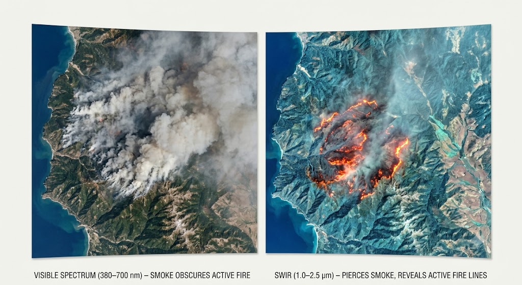
Wildfire Response and Management
During an active forest fire, visible sensors are blinded by massive plumes of smoke. Because SWIR light passes directly through smoke particles, emergency responders use SWIR satellite data to pinpoint the exact location of active burning fire lines and hotspots beneath the canopy. Furthermore, because charred wood reflects SWIR differently than healthy vegetation, it is used post-fire to accurately map burn severity.
Precision Agriculture and Climate Monitoring
In agriculture, SWIR is heavily utilized to detect crop water stress before it becomes visible. When a plant dehydrates, its internal water content drops, causing it to reflect more SWIR light. Combining SWIR data with Near-Infrared (NIR) data allows scientists to calculate the Normalized Difference Moisture Index (NDMI). Furthermore, narrow-band SWIR sensors can pinpoint specific gas absorption features, making them highly effective tools for detecting localized industrial methane leaks or verifying agricultural carbon abatement.
Mining and Geology
For the mining industry, exploration is traditionally an expensive gamble. Minerals containing aluminum-hydroxyl (Al-OH) or magnesium-hydroxyl (Mg-OH) bonds, along with carbonates, exhibit sharp, unique absorption “fingerprints” in the SWIR range. By analyzing commercial SWIR data, geologists can remotely map indicator minerals across vast, inaccessible terrains, drastically narrowing down potential drilling sites.
The Horizon of Orbital SWIR
As satellite manufacturing shifts toward smaller, more cost-effective constellations, SWIR technology is becoming increasingly accessible. Hyperspectral small-satellite constellations are beginning to slice the SWIR spectrum into hundreds of narrow bands, promising even finer chemical and material identification from space. By peeling back the limitations of human sight, satellite SWIR is fundamentally changing how we protect our environment, manage our resources, and secure sovereign borders.
To learn more about how upcoming constellations are changing the unit economics of environmental tracking, you can watch this Interview with LC60 AI Founder on the SWIRSAT Mission, where he outlines their goals for low-cost methane and carbon dioxide monitoring.