


CEO & Founder
of LC60 AI Ltd
LC60 AI, an Australian Earth Observation company, is expanding into the MENA region to deliver AI-powered geospatial analytics for agriculture, climate monitoring and emissions tracking. Headquartered in Perth and led by CEO & Founder Venkat Pillay, the company leverages advanced satellite technology with proprietary AI algorithms to provide actionable insights for governments, commercial enterprises and researchers. It’s upcoming SWIRSAT constellation will further enhance capabilities by offering high sensitivity Short Wave Infrared imaging for emissions and environmental monitoring. In this interview, Venkat shares the company’s vision for the region, outlines key strategic partnerships, and the role of EO data in addressing key regional challenges like water scarcity, food security and carbon emissions reduction.
Venkat Pillay is the CEO & Founder of LC60 AI Ltd (LC60 AI), a satellite-enabled Earth Observation company established in 2019 in Perth, Australia. He leads the strategic vision and growth of LC60 AI, spearheading the development of cutting-edge satellite constellations, data analytics solutions, and insights through the proprietary EONet60 platform for industries including agriculture, environmental monitoring and climate assessment.
With over 16 years of experience in satellite missions across Southeast Asia, Venkat has also contributed as a Program Manager and Systems Engineer for Canadian and U.S. government satellite programs. He holds multiple patents in UAV-LEO satellite integrated operations and data fusion, granted in the USA, Australia, Malaysia and Singapore, reinforcing his expertise in advanced space technologies.
What motivated LC60 AI to expand its presence in the MENA region, and what unique opportunities do you see for satellite-driven solutions in this market?
The MENA region is undergoing rapid technological transformation and there is a growing demand for Earth Observation (EO) data to support strategic decision-making across agriculture, climate monitoring, resource management, and sustainability initiatives. Our AI-powered geospatial analytics provide actionable intelligence that aligns with regional priorities such as food security, water conservation, and emissions reduction.
Expanding into MENA allows us to form high impact collaborations such as with governments and enterprises to deliver tailored EO solutions that directly address these pressing challenges.
for a Malaysian State Enterprise
How does LC60 AI plan to collaborate with local governments, businesses, and research institutions in the region to maximize the impact of your Earth Observation services?
Collaboration is key to our strategy in MENA. We plan to actively engage with government agencies, industry leaders, and academic institutions to integrate our EO capabilities into regional initiatives. Our focus is on forming strategic partnerships that enable data sharing, technology transfer, and capacity building. Additionally, we are working on joint research projects to develop AI-driven applications that align with the region’s economic and sustainability goals.
With the upcoming launch of the SWIRSAT constellation in 2026, what new capabilities will it bring to the MENA region, particularly in agriculture, carbon monitoring, and climate resilience?
SWIRSAT will introduce cutting-edge Short-Wave Infrared (SWIR) imaging capabilities, enabling the detection of emissions as low as 50 kg/hr with near-daily revisit times. This is particularly beneficial for monitoring methane emissions in oil and gas operations, supporting both regulatory compliance and decarbonization targets across the region. In agriculture, SWIRSAT will provide high-precision insights into soil moisture, crop health, and yield prediction, empowering farmers to optimize resource use and mitigate climate related risks. Additionally, the satellite’s climate monitoring capabilities will aid in tracking desertification, water scarcity, and natural disasters.
What makes SWIRSAT valuable to the Middle East region is its ability to deliver sovereign EO data integrated with our AI analytics platforms, ensuring local stakeholders receive timely and decision-ready intelligence. This will support environmental reporting, national sustainability strategies and participation in carbon markets and open the door for regional cooperation in space-based innovation.
How does LC60 AI’s AI-driven geospatial analytics differentiate itself from other satellite-based EO service providers in terms of accuracy, cost-efficiency, and data integration?
Our AI-powered platform integrates multispectral, SAR, SWIR, and GNSS-R datasets, delivering superior accuracy in environmental and industrial monitoring. By combining our proprietary AI algorithms with high-resolution imagery, we are able to provide near real-time, automated analytics that reduce data processing time and costs. Furthermore, our API-driven architecture allows seamless integration with existing systems and business workflows, ensuring that organizations can derive insights without extensive technical expertise.
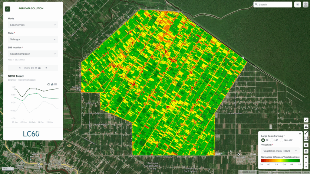
How can your Agri Data Analytics and AG60 mobile application help farmers in MENA overcome challenges such as water scarcity, soil degradation, and climate variability?
Our Agri Data Analytics solution and AG60 mobile application provide near real-time, satellite-derived insights on soil moisture, crop health, and vegetation stress. This enables farmers to optimize irrigation schedules, detect early signs of drought stress, and improve land-use efficiency. Additionally, by integrating cadastral and farm level data, we support precision agriculture strategies tailored to smallholder farmers, helping them increase productivity while conserving resources.
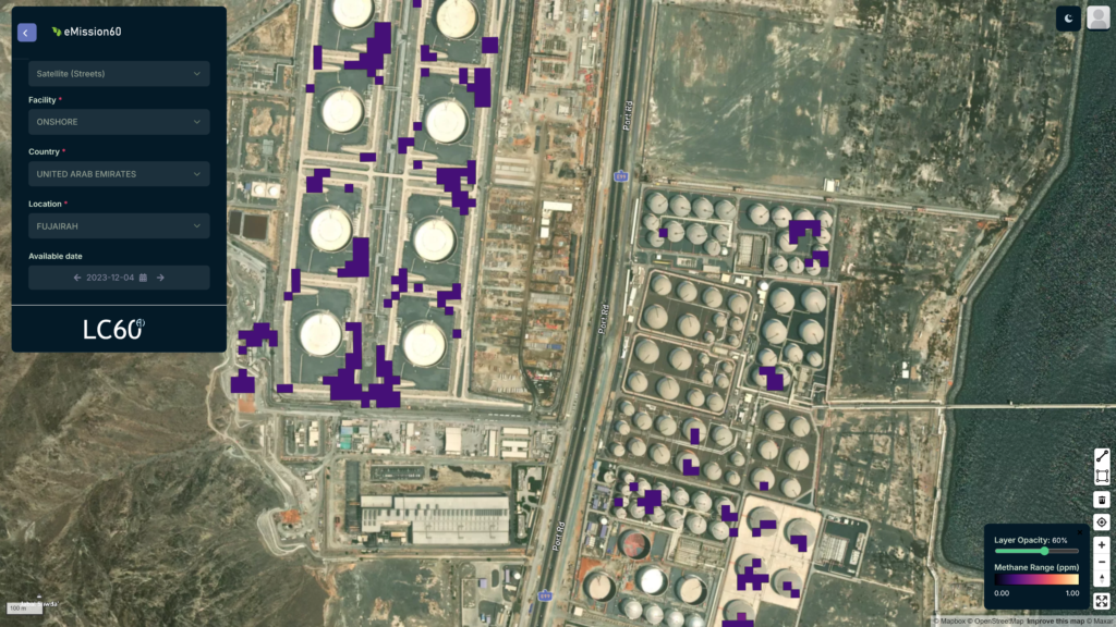
The MENA region is investing in sustainability and emissions reduction. How do CQuest 60 and eMission 60 support these goals through accurate carbon and methane monitoring?
CQuest 60 leverages high-resolution satellite imagery and AI-driven analytics to quantify carbon stock in forests and agricultural land, enabling organizations to track deforestation and participate in carbon credit markets with confidence. eMission 60 provides near real-time methane plume detection, allowing industries to identify and mitigate emissions efficiently. These solutions directly align with sustainability goals set by regional governments and international frameworks such as UN REDD+ and OGMP 2.0.
Given the region’s evolving regulatory landscape, how does LC60 AI ensure that its data and analytics comply with local environmental policies and international frameworks like UN REDD+ and OGMP 2.0?
Compliance is a top priority in our platform architecture. Our analytics platforms are designed to align with global and regional regulatory frameworks, ensuring that organizations meet reporting standards and sustainability commitments. We also work closely with regulatory agencies to ensure our solutions meet specific compliance requirements, and our AI models are continuously updated to reflect changes in environmental policies.
What challenges do you anticipate in deploying and scaling satellite-based solutions across MENA’s diverse industries, and how do you plan to address them?
One of the main challenges is raising awareness and ensuring end-users fully understand the value of satellite-driven insights. To address this, we focus on education and capacity building through workshops, demonstrations and pilot programs. Additionally, some industries require customized data processing solutions, so we provide tailored API integrations to ensure seamless adoption. Connectivity and data infrastructure can also be a hurdle in remote areas, which we mitigate through cloud-based platforms and partnerships with local technology providers.
What role do partnerships with space agencies, environmental organizations, and commercial enterprises play in LC60 AI’s long-term strategy for the region?
Partnerships are fundamental to our growth strategy in MENA. By collaborating with space agencies, we can enhance satellite data accessibility and contribute to regional space initiatives. Environmental organizations help us align our solutions with sustainability goals, while commercial enterprises enable us to scale deployment across key industries. These collaborations foster innovation, drive market adoption, and maximize the impact of EO analytics in the region.

Looking ahead, what key milestones and innovations can we expect from LC60 AI over the next five years in the MENA market?
Over the next five years, we plan to:
Support regional governments and industries in achieving net-zero and sustainability goals through advanced EO capabilities.
Launch the SWIRSAT constellation and expand its applications for agriculture, climate monitoring, and emissions detection.
Strengthen our presence in MENA through local offices and regional partnerships.
Enhance our AI-driven analytics to provide even more precise and automated insights.
Develop new products that integrate space-based data with IoT and ground sensors for a holistic monitoring approach.
You can find more interviews and articles on the UAE space ecosystem in our latest magazine.